Project: Two Options
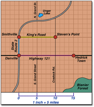
You can use a map to find out how far apart places are. A map cannot be large enough to show real distance. Some maps have a distance scale. The distance scale uses a small measure to stand for a larger measure.
Map is borrowed from the OW Project page-
Course: History And Geography 300 Unit: 10. COMMUNITIES IN REVIEW Assignment: 10. Project: Two Options
Map is borrowed from the OW Project page-
Course: History And Geography 300 Unit: 10. COMMUNITIES IN REVIEW Assignment: 10. Project: Two Options
Directions:
1. Using the above distance scale, one inch represents how many miles of real distance?
2. Using the map above how many miles of real distance would be represented by four inches?
3. If you traveled along King's Road from Steven's Point to Smithville, how far would you travel?
4. If you go from Danville to Hedrick Town how far would you travel?
5. If you travel from Smithville to Danville, how far would you go?
(Record your answers in the OW box. Be sure to number each one. Label your answers correctly.)
